
Mounts Palay-Palay–Mataas-na-Gulod Protected Landscape: A Natural Wonder Near Manila
- KGM Resorts
- Jan 28
- 9 min read

A Protected Gem of Southern Luzon

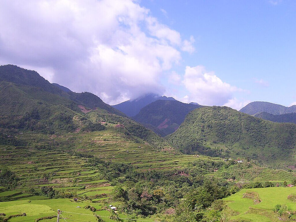
Just a few hours south of Metro Manila lies a sanctuary of volcanic peaks, lush forests, and rare wildlife: the Mounts Palay-Palay–Mataas-na-Gulod Protected Landscape. This sprawling natural reserve captivates visitors with its dramatic terrain—where towering cliffs and winding trails offer a striking contrast to the bustling urban sprawl just beyond its borders.
At its heart is the iconic Mount Pico de Loro, famed for its parrot-beak-shaped summit that draws hikers and photographers alike. But the landscape is more than a photogenic destination; it shelters the last remaining lowland forest in Cavite, making it an essential stronghold for biodiversity and ecological stability. From endemic birds to ancient hardwood trees, the area serves as a living museum of Luzon’s vanishing wilderness.
Whether you're chasing your next outdoor challenge or simply craving a meaningful escape into nature, this protected area blends adventure with environmental consciousness. Its proximity to Manila, Tagaytay, and Batangas makes it an ideal day hike or weekend getaway for anyone eager to experience the natural and cultural riches of Southern Luzon.
Where Is It? – Location and Accessibility
Nestled between the provinces of Cavite and Batangas in the CALABARZON region, the Mounts Palay-Palay–Mataas-na-Gulod Protected Landscape is one of the most accessible hiking and nature destinations near Metro Manila. It lies approximately 80 to 100 kilometers south of Manila, making it an ideal day trip or weekend escape for urban adventurers and eco-tourists alike.
The most popular entry point is via the Ternate–Nasugbu Road, which winds through lush forest cover and offers scenic glimpses of the surrounding mountains. Travelers coming from Metro Manila can take a bus or private vehicle to Ternate, Cavite, passing through CAVITEX, then proceeding toward Maragondon and eventually the DENR station near Sitio Magnetic Hill—the jump-off for Pico de Loro.
From Tagaytay, head south via Amadeo or Alfonso, then link up to Ternate–Nasugbu Road. Visitors from Batangas, particularly the town of Nasugbu, can approach the park from the southern side—although the northern Cavite access is more common for first-timers.
Regardless of your origin, expect a mix of paved roads and mountain curves. For those relying on public transport, some portions may require tricycles or habal-habal rides to reach the final trailheads.

What Makes It Unique – Natural and Cultural Highlights
Mount Pico de Loro (Parrot’s Beak)
This jagged rock formation rising from the summit of Mount Palay-Palay resembles a parrot’s beak, earning it the name Pico de Loro. It’s one of the most iconic photo spots in Southern Luzon, offering panoramic views of forests, coves, and the West Philippine Sea—perfect for adventurous hikers and photographers.
Last Lowland Forest in Cavite
Mounts Palay-Palay–Mataas-na-Gulod shelters the last remaining lowland dipterocarp forest in Cavite, a critical habitat for biodiversity. The forest is teeming with native trees, mossy ferns, orchids, and other plant species—many of which are endemic or threatened, making this protected area a vital ecological stronghold.
Birdwatcher’s Paradise
This protected landscape is a haven for over 80 species of birds, including endangered raptors and forest specialists. Sightings of the Luzon tarictic hornbill, Philippine serpent eagle, and Guaiabero parrot make it a rewarding destination for birdwatchers and conservationists alike.
Cultural Significance
Beyond its natural wonders, the area is steeped in local lore. Indigenous communities once considered the mountains sacred, and legends speak of spirits and guardians protecting the forest. The towering rock formations and serene landscapes evoke reverence, contributing to its identity as a spiritual and cultural site.
Top Trails – Hiking Options in the Protected Landscape
Main Route: Pico de Loro Trail (Ternate Side)
The most popular trail is the Pico de Loro Trail, accessed via the DENR outpost in Ternate, Cavite. This route leads hikers through lush lowland forest, bamboo groves, and eventually to the rocky summit of Pico de Loro, with the iconic Monolith—a towering vertical rock formation that challenges thrill-seekers with a near-vertical climb.
Trail Difficulty: Moderate to Hard
The trail is well-marked but includes steep ascents, muddy patches during wet season, and some exposed ridge walking. The final push to the summit requires good balance and caution, especially if attempting the monolith.
Trail Duration: 4–6 Hours Round-Trip
Depending on your pace and stops, most day hikers can reach the summit in 2.5–3.5 hours and descend in about 1.5–2 hours. Early morning hikes are highly recommended for cooler temperatures and clearer views.
Guide Requirements and DENR Registration
As of recent regulations, hikers are required to register at the DENR station in Ternate. Guides may not be mandatory for experienced hikers, but they are strongly recommended, especially for first-timers or during less busy seasons. They also provide insights into the area’s ecology and ensure safer navigation.
Flora and Fauna – A Biodiversity Hotspot
The Mounts Palay-Palay–Mataas-na-Gulod Protected Landscape is one of the last remaining lowland forest ecosystems in Cavite and southern Luzon. This ecological treasure supports an incredible array of endemic and threatened species, making it a crucial area for conservation and nature appreciation.
Flora: Lush and Layered Forests
The landscape is rich with dipterocarp trees such as Shorea and Dipterocarpus species, which form the backbone of Luzon’s tropical forests. Beneath the canopy, you’ll find a thriving understory of vines, ferns, and rare orchids, many of which are endemic and highly sensitive to disturbance. These forest layers provide shelter, food, and nesting areas for various wildlife species, contributing to the park’s ecological balance.
Fauna: A Haven for Endemic Wildlife
Birdwatchers and naturalists will find this area especially rewarding. The protected landscape is home to:
Philippine Eagle-Owl (Bubo philippensis) – The country’s largest owl, often heard but rarely seen.
Luzon Hornbill (Penelopides manillae) – A forest-dependent species with a distinctive casque and loud cackling calls.
Luzon Bleeding-heart Dove – A shy, ground-dwelling bird known for the red mark on its chest, symbolizing a “bleeding heart.”
Monitor Lizards, flying lizards (Draco sp.), and forest snakes also inhabit the area, thriving in the dense vegetation.
Small mammals like civet cats and tree shrews make up the hidden wildlife often glimpsed by the quiet and observant hiker.
Conservation Significance
As lowland forests in Luzon rapidly decline due to development and illegal logging, this protected area plays a vital role in biodiversity conservation. It serves as a genetic reservoir, a carbon sink, and a sanctuary for species that are no longer common in other parts of the region. Conservation efforts by the DENR, local guides, and eco-tourism initiatives help safeguard this critical habitat.

Best Time to Visit – Mounts Palay-Palay–Mataas-na-Gulod Protected Landscape
Planning your hike to the Mounts Palay-Palay–Mataas-na-Gulod Protected Landscape—especially to Pico de Loro—is all about timing. Weather conditions play a big role in both the safety and enjoyment of your adventure.
Dry Season: December to May
This is the ideal window for hiking, with minimal rainfall, more stable trails, and clearer views. The months of March to May are particularly popular for summer adventurers, but December to February offers cooler hiking temperatures and lush greenery after the rainy season.
Sunrise and Sunset Treks
For those chasing unforgettable photos, early morning or late afternoon treks are highly recommended. Sunrise hikes reward climbers with stunning views from the summit of Pico de Loro, while sunsets cast dramatic hues over the forests and cliffs. Always start early to avoid heat and crowds, especially on weekends and holidays.
Rainy Season: June to November
Hiking during the monsoon season can be risky, with slippery trails, reduced visibility, and higher chances of landslides or flash floods. Some trails may be temporarily closed by the DENR for safety or restoration. If you plan to visit during these months, monitor weather advisories and check with the local DENR office in advance.
Tips for a Responsible Visit
Exploring the Mounts Palay-Palay–Mataas-na-Gulod Protected Landscape offers incredible opportunities—but it also comes with responsibilities. As a protected area, visitors must tread lightly and ensure their presence doesn’t harm the ecosystem or disturb the experience for others.
What to Bring
Hiking shoes with good grip for rugged trails
Reusable water bottles and trail snacks to stay energized
Sunblock, a hat, and light clothing for sun protection
Eco-bag for your trash—pack out what you pack in
Flashlight or headlamp for early or late treks
Leave the plastic behind—this is a zero-waste zone.
Environmental Ethics
Leave No Trace: Don’t leave trash, vandalize trees or rocks, or damage any part of the trail.
Stay on marked paths to avoid trampling vegetation.
No picking of flowers, plants, or disturbing wildlife—this is a biodiversity hotspot, not a botanical garden.
Respect noise levels—enjoy the sounds of nature and avoid loud music or shouting.
For Drone Pilots and Photographers
Check drone regulations with DENR or park officials; some areas may have restrictions.
Fly only in open, non-crowded areas and avoid disturbing birds.
Golden hour (sunrise/sunset) is perfect for shots—plan accordingly.
Respect other hikers’ space and experience when filming or taking portraits.
Campers and Day Trekkers
Overnight camping may require special permits—check in advance.
Use designated rest areas or campsites—avoid setting up tents in sensitive zones.
Don’t light fires—even for cooking. Bring pre-packed meals or portable burners if allowed.
By visiting responsibly, you help protect one of Luzon’s last lowland forests and ensure future hikers can enjoy its magic too.

Nearby Attractions – More to See Around the Landscape
The adventure doesn’t have to end at the summit of Pico de Loro. The surrounding areas of Cavite and Batangas offer scenic spots perfect for post-hike relaxation or extended eco-escapes.
Kaybiang Tunnel
Just a short drive from the trailhead, Kaybiang Tunnel is the longest road tunnel in the Philippines. It offers a thrilling ride through a mountain pass and serves as a scenic gateway between Ternate (Cavite) and Nasugbu (Batangas). The area is also popular with bikers and weekend road-trippers.
Nasugbu Beaches
After a tiring hike, reward yourself with a refreshing swim at the nearby Nasugbu beaches. Just 30–45 minutes away, these coastlines offer white sands, calm waters, and quiet resorts—perfect for relaxation or even a seaside meal. Some popular spots include Laiya, Calayo, and Papaya Cove.
Tagaytay Side Trip
A detour to Tagaytay makes for a delightful end to your nature trip. Just over an hour away, it offers cool weather, sweeping views of Taal Volcano, and a wide selection of restaurants, cafés, and local delicacies. Ideal for food lovers and those craving a little comfort after the rugged trails.
Whether you’re into scenic drives, beach hopping, or food trips, these nearby attractions make your visit to the protected landscape even more worthwhile.
Conservation and Protection Status
Despite its natural beauty and ecological significance, Mounts Palay-Palay–Mataas-na-Gulod Protected Landscape (MPPMNGPL) faces increasing pressure from human activity. Conservation efforts, led by government and local stakeholders, are key to preserving this vital green space.
Legal Protection Under NIPAS
This area is officially designated as a Protected Landscape under the National Integrated Protected Areas System (NIPAS) Act of 1992 and strengthened under the Expanded NIPAS (E-NIPAS) Act of 2018. This classification ensures the preservation of biodiversity while allowing for regulated eco-tourism and scientific research.
Role of DENR and Local NGOs
The Department of Environment and Natural Resources (DENR) is the primary agency responsible for managing the park, overseeing trail regulations, permit systems, and forest monitoring. Local NGOs and volunteer organizations also assist in environmental education, reforestation efforts, and visitor orientation programs to promote responsible travel.
Conservation Challenges
Despite protection, MPPMNGPL continues to face several threats:
Illegal logging and poaching still occur in less monitored zones.
Unregulated tourism leads to trail degradation, waste, and habitat disturbance.
Urban sprawl from nearby provinces poses long-term pressure on forest boundaries.
Continued collaboration between government agencies, communities, and visitors is essential to maintaining the ecological balance and integrity of the landscape.

Takeaway – A Landscape Worth Protecting and Exploring
Mounts Palay-Palay–Mataas-na-Gulod is more than just a scenic hiking destination—it's a living sanctuary of Luzon's remaining lowland forests, endemic species, and cultural echoes. With its signature peak, Pico de Loro, towering over a sea of green, this protected landscape reminds us of the beauty that still exists just a few hours from the urban bustle of Metro Manila.
For hikers, birdwatchers, and conservation-minded travelers, the trails of Palay-Palay offer more than an adventure—they offer a chance to connect with nature, witness biodiversity in action, and be part of a growing movement toward responsible eco-tourism in the Philippines.
Explore mindfully, share your experiences, and help protect one of Southern Luzon’s most valuable ecological treasures.
Frequently Asked Questions
Do I need a permit to hike Pico de Loro?
Yes, hikers must register at the DENR station along the Ternate–Nasugbu Road. A minimal environmental fee applies, and guides are required for first-time hikers.
Is the monolith climb still open?
No. The iconic monolith beside Pico de Loro's summit remains closed to climbers for safety and conservation reasons. Viewing is allowed but climbing it is prohibited.
Are there overnight camping sites?
Camping is permitted in designated areas, though availability may vary. Always check with local authorities or guides before planning an overnight stay.
Is it beginner-friendly?
The main Pico de Loro trail is suitable for moderate-level hikers. Beginners can complete the hike with proper pacing, hydration, and a guide. However, the trail has steep sections and requires stamina.


Mounts Palay-Palay is a mountain hike in every part of an island. A forest and a landscape in a biodiversity.
At its heart is the iconic Mount Pico de Loro, famed for its parrot-beak-shaped summit that draws hikers and photographers alike. But the landscape is more than a photogenic destination; it shelters the last remaining lowland forest in Cavite, making it an essential stronghold for biodiversity and ecological stability. From endemic birds to ancient hardwood trees, the area serves as a living museum of Luzon’s vanishing wilderness.
This jagged rock formation rising from the summit of Mount Palay-Palay resembles a parrot’s beak, earning it the name Pico de Loro. It’s one of the most iconic photo spots in Southern Luzon, offering panoramic views of forests, coves, and the West Philippine Sea—perfect for adventurous hikers and photographers.
If you're planning a trip to this beautiful sanctuary, here are two key insights to keep in mind for your visit...The landscape is home to the very last lowland dipterocarp forest in Cavite. This makes it a vital ecological stronghold where you can see rare endemic species, like the Luzon tarictic hornbill, in their natural habitat rather than just a zoo...While the Pico de Loro trail is famous for its "Parrot’s Beak" summit, it’s a serious trek that takes 4–6 hours round-trip. You'll need to register at the DENR station in Ternate and prepare for steep, muddy climbs to reach those iconic panoramic views...