
Mount Binuluan, Kalinga
- KGM Resorts
- Sep 8, 2025
- 11 min read

A Fiery Giant in the Cordillera Mountains
Rising like a silent sentinel in the rugged heart of the Cordillera Central, Mount Binuluan—also known as Mount Ambalatungan—is one of the Philippines’ lesser-known yet geologically significant volcanoes. Classified as an active stratovolcano, it is marked not by explosive eruptions in modern memory, but by fumarolic activity, where steam and gases hiss from vents and fissures near its base. These telltale signs of geothermal energy hint at a restless world beneath its forested slopes.
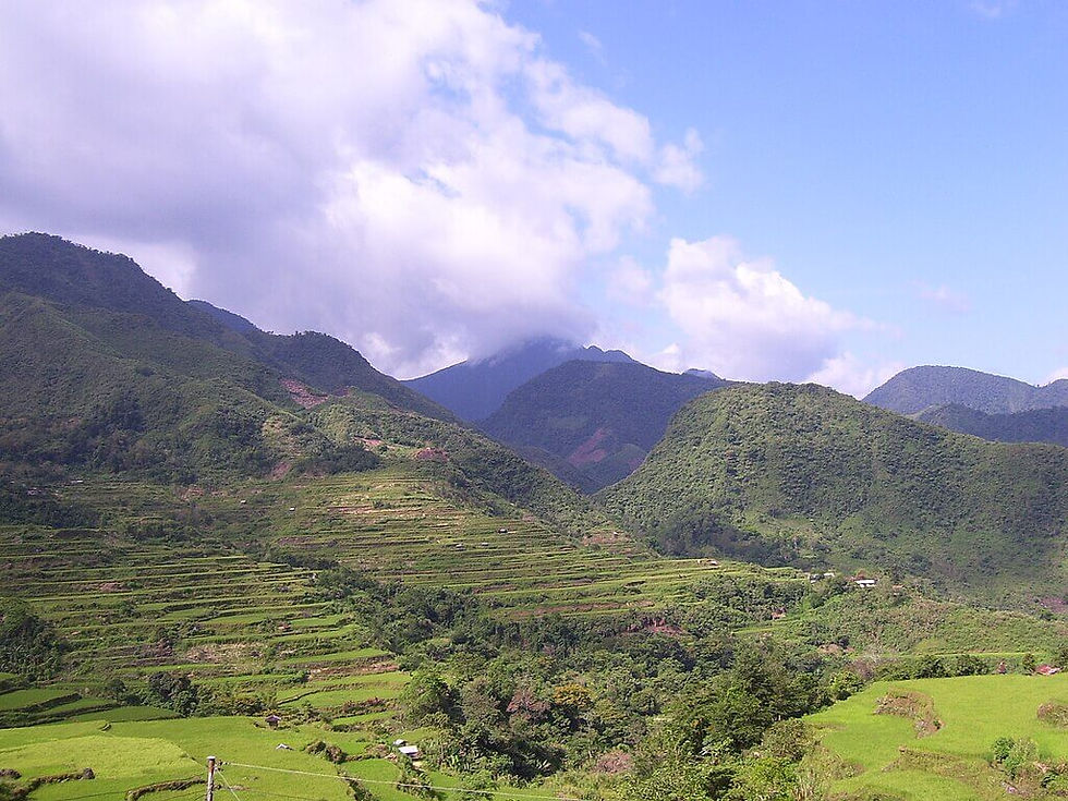
Towering at around 2,329 meters above sea level, Mount Binuluan is both a geological landmark and a natural wonder within Kalinga Province. Its commanding presence is deeply woven into the cultural and ecological tapestry of the region—guarding sacred ancestral lands, feeding rivers that nourish rice terraces, and inspiring awe in those who hike its remote terrain.
Despite its quiet demeanor, Mount Binuluan remains enigmatic—a mountain cloaked in clouds and mystery. For the indigenous Kalinga people, it is not just part of the landscape, but a place of memory, story, and survival. Today, as more adventurers seek out the off-the-beaten-path treasures of the Philippines, Mount Binuluan stands waiting—its trails untamed, its secrets unspoken, its volcanic heart still quietly alive.
Geographic Location and Setting
Mount Binuluan is nestled in the Cordillera Central Mountain range, one of the most rugged and biodiverse regions in the Philippines. Geographically, it lies within the province of Kalinga, straddling the municipalities of Pasil, Lubuagan, and Tinglayan—a convergence of ancestral domains and rich cultural heritage.
Sitting at an elevation of approximately 2,329 meters above sea level, Mount Binuluan forms part of the Ambalatungan Mountain Range, a subrange of the broader Cordillera system. Its lofty height offers sweeping views over Kalinga’s dramatic terrain—carved by rivers, rice terraces, and mist-shrouded peaks.
Nearby natural landmarks add to the mountain’s significance:
To the east, the mighty Chico River snakes its way through valleys, playing a vital role in irrigation and indigenous lifeways.
To the west, the Pasil River nourishes the forests and rice fields around Pasil town.
And to the south, the iconic Sleeping Beauty Mountain looms—another legendary peak rooted in Kalinga folklore.
This strategic location makes Mount Binuluan not only a striking geological feature but also a crucial part of Kalinga’s ecological balance, hydrological network, and cultural geography.

Volcanic Activity and Geological Features
Mount Binuluan is classified as a stratovolcano, formed by successive layers of hardened lava, volcanic ash, and pyroclastic material. It belongs to the Luzon Volcanic Arc, a tectonically active zone shaped by the subduction of the Philippine Sea Plate beneath the Eurasian Plate. This geological context makes Binuluan a potential hotspot for geothermal and volcanic activity.
Active Geothermal Zones
While not frequently erupting, Mount Binuluan exhibits signs of ongoing geothermal activity:
Fumaroles vent high-temperature gases, including sulfur dioxide and steam, from fissures in the mountainside.
Sulfur vents stain the terrain with yellowish mineral deposits and give the area its characteristic sulfuric smell.
Hot springs in nearby communities like Pasil are believed to be connected to subsurface volcanic heat, offering both recreational and therapeutic use.
These geothermal manifestations suggest an active but subtle magmatic system beneath the volcano, contributing to the region’s rich potential for renewable geothermal energy and scientific interest.
Historical Eruption
There is an unconfirmed phreatic eruption recorded in 1952, which reportedly caused localized hazards, including:
Steam explosions
Lahars or mudflows
Temporary evacuation of nearby settlements
However, due to the lack of instrumentation and direct observation at the time, this event remains classified as unverified by the Philippine Institute of Volcanology and Seismology (PHIVOLCS). Despite its dormant outward appearance, the presence of thermal anomalies signals that Mount Binuluan remains potentially active and should be treated with caution.
Fumarolic Fields and Hot Springs of Mount Binuluan
Mount Binuluan isn’t just a towering stratovolcano—it’s a living, breathing geothermal system. Across its rugged terrain, several fumarolic fields and hot springs bubble and hiss, offering scientists, adventurers, and curious travelers a window into the Earth's inner workings.
Bu-ot Fumarole Field (Pasil River)
Located along the banks of the Pasil River, the Bu-ot Fumarole Field is one of the most accessible geothermal zones near the volcano. Here, white steam vents rise dramatically from rock fissures beside flowing water. The combination of cool river currents and geothermal outflow makes this spot visually striking and geologically fascinating. The strong sulfur smell and mineral-stained rocks are clear indicators of volcanic activity beneath the surface.
Bum-bag Fumarole Fields
The Bum-bag geothermal area comprises three main fumarolic zones, each exhibiting distinct geothermal activity:
Zone 1 features vigorous steam vents and sulfur deposits.
Zone 2 includes muddy thermal pools and gas-emitting cracks.
Zone 3 lies closer to higher elevation, with intermittent emissions depending on rainfall and pressure buildup.
These sites, though relatively remote, are of high interest for volcanology and renewable energy studies.
Sugo-oc and Sun-ut Hot Springs
These natural springs are nestled within forested slopes and valley ridges, offering warm waters rich in minerals. Locals have long visited Sugo-oc and Sun-ut not just for bathing, but for traditional healing. Surrounded by lush greenery, these sites are ideal for eco-tourism development, though they remain largely untouched by commercial infrastructure.
Bunog Falls – A Geothermal Gem
Bunog Falls combines the best of both worlds: a scenic waterfall cascading near geothermal emissions. Warm mist rises in pockets around the base, where thermal waters mix subtly with colder mountain runoff. With proper infrastructure and sustainability measures, Bunog Falls has the potential to become a standout nature-tourism site in Kalinga, offering guided eco-treks, cultural immersion, and scientific education.

Biodiversity and Natural Environment
Mount Binuluan’s remoteness and elevation within the Cordillera Central make it an ecological stronghold for both flora and fauna. The region’s rugged terrain, intermittent geothermal activity, and minimal human intrusion have allowed it to remain relatively untouched, preserving critical habitats for endemic and rare species found only in the Northern Luzon highlands.
Remote and Untouched Forest Landscapes
The mountain is cloaked in dense montane and mossy forests, particularly on its upper slopes. These forest types are vital carbon sinks and play a crucial role in watershed stability. Because of the limited accessibility and absence of large-scale development, Mount Binuluan’s ecosystem remains largely intact, offering a sanctuary for wildlife and native plant life. Canopies of tree ferns, dwarf bamboos, and dipterocarps dominate, interwoven with lichen and moss-covered rocks.
Potential Habitat for Rare and Endemic Species
While comprehensive biological surveys are limited, the region is believed to harbor Cordillera endemics, including:
Luzon bushy-tailed cloud rat
Philippine warty pig
Northern Luzon tree squirrel
Birds like the Cordillera ground warbler, Luzon bleeding-heart, and Philippine hawk-eagle
These species thrive in undisturbed high-altitude environments like those found around Binuluan, making the area important for future conservation and biodiversity research.
Seasonal Rivers and Dynamic Terrain
Multiple seasonal streams and rivers—including tributaries of the Chico and Pasil Rivers—crisscross the volcanic terrain. These waterways are lifelines for surrounding communities and support freshwater ecosystems. During the rainy season, these river systems swell dramatically, creating temporary wetlands and aquatic breeding grounds.
The mountain’s varied elevations and geothermal zones also support microhabitats, which contribute to the diversity of plant and animal species adapted to specific temperature and moisture ranges—from cool, misty ridgelines to humid valley forests near sulfur vents.
Indigenous Communities and Cultural Significance
Mount Binuluan is more than just a volcanic feature—it is a sacred landmark deeply intertwined with the identity, traditions, and spiritual beliefs of the Kalinga people. The surrounding areas—particularly Pasil, Lubuagan, and Tinglayan—are part of ancestral domains long inhabited by Indigenous Kalinga communities, whose culture is one of the richest in the Cordillera region.
Land of the Kalinga People
The mountain is located within territories traditionally governed by bodong or peace pacts—intertribal agreements maintained through diplomacy and oral law. The Kalinga people are renowned for their:
Traditional tattooing practices, as preserved by elders like Whang-od.
Strong communal land stewardship, based on a deep respect for nature.
Generations of oral tradition that shape how the landscape is understood and protected.
Mount Binuluan, in this context, is not just a peak but a presence—a spiritual guardian in the eyes of many locals.
Oral Histories and Sacred Spaces
Many elders in the region speak of the mountain as a sacred entity, often associating its fumaroles and hot springs with ancestral spirits. Some ridgelines and surrounding areas are off-limits for farming or development, not just due to terrain, but because they are considered spiritually sensitive or “owned” by the unseen dwellers of the mountain.
Elders tell of signs from the volcano—such as rumbling sounds or sulfuric odors—as omens or messages. These interpretations play a role in decisions around land use, agriculture, and travel, especially in more remote sitios.
Stories of Spirits, Warnings, and Reverence
Mount Binuluan is associated with myths of protection and punishment. Some stories recount how the spirits of the mountain guard the tribe, unleashing heat and tremors to ward off danger or warn of disrespect. Others describe natural features like hot springs or caves as passageways to the world of spirits.
Rather than fearing the volcano, the Kalinga people treat it with deference—a relationship based on mutual respect and balance. Visitors are encouraged to recognize these cultural dimensions and act with mindfulness and humility while trekking or exploring the area.

Trekking and Ecotourism Potential
Mount Binuluan remains one of the least-explored volcanic peaks in the Philippines—not because it lacks grandeur, but because of its remote location, challenging terrain, and sacred status among the Kalinga people. Still, for those seeking raw adventure and authentic cultural immersion, the mountain offers a unique opportunity for off-the-beaten-path ecotourism.
Limited Access, Authentic Experience
Currently, access to Mount Binuluan is limited. There are no formal tourism facilities, signage, or established campsites. Trekking here is not for casual tourists but rather for seasoned hikers or researchers. The journey is best undertaken with the guidance of local elders or accredited guides from the surrounding towns of Pasil, Lubuagan, or Tinglayan.
The need for guides isn’t just for safety—it’s also a sign of respect for indigenous customs and ensures that trekking aligns with local protocols and conservation ethics.
Trekking Routes and Trailheads
Potential jump-off points for treks include:
Pasil: Known for access to fumarolic fields and hot springs.
Lubuagan: Offers routes that pass through tribal villages and ancestral domains.
Tinglayan: A scenic approach near the famed Sleeping Beauty Mountain.
These trails are often unmarked and traverse rice terraces, river crossings, dense forests, and rocky ridgelines, requiring physical stamina and good navigation. Travel times vary greatly depending on the route, weather, and trail conditions.
Best Season and Difficulty Level
Best time to trek: November to May, during the dry season, when trails are less slippery and river levels are manageable.
Difficulty level: Intermediate to advanced. The remoteness, lack of infrastructure, and potential for landslides or river swells during the rainy season make it a demanding but rewarding endeavor.
It’s important for visitors to prepare properly—with proper gear, sufficient food and water, and permissions from local authorities or community leaders.
A Trek with Purpose
Trekking Mount Binuluan is not just a hike—it’s a deep cultural and ecological immersion. Along the way, travelers may encounter fumaroles, hot springs, wildlife sightings, and Kalinga elders who share tales of the mountain’s spiritual past.
For eco-conscious travelers, this is an opportunity to promote community-based tourism, support cultural preservation, and raise awareness about the fragile volcanic and forest ecosystems of the Cordillera region.
Safety and Environmental Concerns
While Mount Binuluan is a captivating destination, it is also geologically active and ecologically fragile, requiring cautious and well-informed exploration. Safety and environmental responsibility should be a top priority for any traveler or researcher venturing into this remote part of Kalinga.
Natural Hazards to Watch For
Mount Binuluan is classified as an active stratovolcano with fumarolic activity, making the surrounding terrain unpredictable and potentially hazardous:
Toxic Gas Emissions: Fumaroles and sulfur vents emit gases like hydrogen sulfide and sulfur dioxide, which can be harmful or fatal in high concentrations. Visitors should avoid prolonged exposure and stay clear of venting areas.
Unstable Ground: Areas near fumaroles or hot springs may have loose, brittle, or thin crusts, posing a risk of falling into superheated ground or boiling mud.
Flash Floods: During the rainy season, mountain streams can swell rapidly, especially near geothermal sites. Trekking near rivers should be avoided during or after heavy rains.
Environmental Threats and Fragility
Though relatively untouched, the area surrounding Mount Binuluan is not immune to pressures from human activity:
Deforestation in nearby areas for agriculture or timber threatens local biodiversity and increases the risk of soil erosion and landslides.
Unregulated Development—such as unplanned tourism facilities or mining activity—can disturb delicate ecosystems and disrespect indigenous cultural landscapes.
As of now, no formal tourism infrastructure exists on the mountain. This preserves its raw beauty but also demands that visitors take extra care not to cause harm to the environment or put themselves at risk.
Responsible Trekking Is Essential
Without established trails, signposts, or rescue services, trekking Mount Binuluan must be done with extreme caution. This includes:
Hiring experienced local guides familiar with the terrain and customs.
Preparing with the right gear, safety equipment, and communication tools.
Ensuring travel insurance that covers remote hiking or volcanic areas.
Respecting indigenous permissions and rituals, as some areas may be considered sacred or restricted.
Ultimately, visitors are stewards of the land—your presence should leave no trace and contribute to the long-term protection of this powerful natural and cultural landmark.

Conservation and Protection Status
Mount Binuluan, despite its geological and cultural significance, remains largely off the radar for mainstream tourism and government-led conservation. This presents both an opportunity and a challenge: the region’s pristine condition is a result of its inaccessibility and low exposure, but it also means that formal protection and sustainable planning are urgently needed.
Minimal Development, High Ecological Value
At present, Mount Binuluan is not part of any major protected area or ecotourism circuit. The absence of infrastructure—such as designated trails, visitor centers, or interpretive signage—has helped preserve its natural state. However, this also means:
No established park status under NIPAS (National Integrated Protected Areas System).
Limited monitoring or enforcement of environmental safeguards.
Vulnerable to unregulated activity, such as logging or geothermal prospecting.
The region’s high biodiversity potential, combined with its geothermal features and cultural importance, makes it an ideal candidate for future conservation or UNESCO Geopark consideration.
Indigenous Custodianship and Land Rights
Mount Binuluan lies within the ancestral domains of the Kalinga people, whose traditional practices have long served as a de facto conservation system. Through bods (peace pacts), communal rituals, and forest stewardship, the Kalinga have protected sacred forests and ensured sustainable use of natural resources.
Any future conservation effort must:
Respect indigenous land rights and autonomy.
Involve local communities as primary stakeholders and decision-makers.
Acknowledge traditional ecological knowledge as a valuable complement to scientific data.
Without this inclusive approach, well-meaning eco-tourism or government interventions could risk eroding cultural ties and ecological balance.
Frequently Asked Questions (FAQ)
Is Mount Binuluan open for tourism?
Mount Binuluan is not yet a mainstream tourist destination. While there is no formal tourism infrastructure, adventure travelers and researchers occasionally visit the area with assistance from local communities. Access is still limited, and most trips are arranged informally with the help of local guides in nearby barangays.
Can I hike or camp at the summit?
Summit treks are possible but considered challenging due to the rugged terrain, lack of marked trails, and geothermal hazards. Camping may be allowed in certain areas, but there are no designated campsites or safety facilities. It's essential to coordinate with local authorities or elders before planning an ascent.
Are there any guides or permits needed?
Yes. Local guides are strongly recommended—and often required— due to the difficult terrain and cultural protocols. While there may not be an official permit system, visiting ancestral lands typically involves community consent. Travelers should check with the municipal office in Pasil, Lubuagan, or Tinglayan, or through Kalinga-based eco-tour groups.
How do I reach the fumaroles or hot springs?
The fumarolic fields and hot springs (like Bu-ot, Sugo-oc, and Sun-ut) are scattered along river systems near Pasil and Bunog. Reaching them involves hiking through mountain paths or riding habal-habal (motorcycles). As these are remote geothermal sites, going with a local guide who knows the terrain and cultural boundaries is crucial for safety and respect.

Takeaway – The Fiery Heart of Kalinga
Mount Binuluan stands as one of the Philippines’ least explored yet most geologically and culturally intriguing landscapes. Its smoking fumaroles, remote waterfalls, and untamed ridgelines create a picture of raw natural power—a sleeping giant waiting to be understood, not conquered.
More than just a trekking destination, it is a living part of Kalinga’s heritage, woven with the stories of its people and the rhythms of the land. To venture here is to step into a space where nature and tradition remain largely intact—fragile, resilient, and fiercely protected.
Whether you're a geologist seeking geothermal marvels, a trekker craving an off-grid challenge, or a cultural explorer longing to understand Cordillera lore, Mount Binuluan offers a rare kind of discovery—one that asks you to go slowly, tread lightly, and listen deeply.


Mount Binuluan, a rich biodiversity worth to be protected.
Rising like a silent sentinel in the rugged heart of the Cordillera Central, Mount Binuluan—also known as Mount Ambalatungan—is one of the Philippines’ lesser-known yet geologically significant volcanoes. Classified as an active stratovolcano, it is marked not by explosive eruptions in modern memory, but by fumarolic activity, where steam and gases hiss from vents and fissures near its base. These telltale signs of geothermal energy hint at a restless world beneath its forested slopes.
Mt. Binuluan 😍
Mount Binuluan one of the hidden gem in Kalinga...
More than just a trekking destination, it is a living part of Kalinga’s heritage, woven with the stories of its people and the rhythms of the land.