
Earthquakes in the Philippines: Why They Happen and How the Nation Lives with Them

Living on Shifting Ground

The Philippines is one of the most seismically active countries in the world. Situated along the Pacific Ring of Fire and crossed by numerous active fault lines, the archipelago experiences thousands of earthquakes each year. While many are too small to be felt, others can cause significant damage, reshape landscapes, and impact communities across the country.
For millions of Filipinos, earthquakes are not rare events but a part of everyday reality. Schools conduct earthquake drills, buildings are designed with seismic activity in mind, and families are taught basic preparedness measures from an early age. Living in the Philippines means understanding that the ground beneath the islands is constantly shifting as tectonic plates move and interact deep below the Earth's surface.
Yet earthquakes are not only sources of danger. The same geological forces that create seismic activity have also shaped many of the country's mountains, valleys, volcanoes, islands, and natural wonders. Understanding Philippine geology helps explain why the nation possesses such dramatic and diverse landscapes.
Earthquakes have influenced the Philippine landscape, history, and culture for centuries. As a result, preparedness, adaptability, and resilience have become essential parts of life, helping Filipinos face the challenges—and opportunities—created by living on constantly shifting ground.
Table of Contents - Earthquakes in the Philippines
Why Do Earthquakes Happen in the Philippines?
Understanding why earthquakes happen in the Philippines begins with understanding the powerful geological forces beneath the country. The Philippines is located in one of the most active seismic regions on Earth, making earthquakes a regular part of life throughout the archipelago.
The Earth Is Made of Moving Tectonic Plates
The Earth's outer shell is divided into enormous sections called tectonic plates. These plates are constantly moving, although usually at a very slow pace.
When tectonic plates:
Collide with one another
Pull apart
Slide past each other
pressure builds beneath the Earth's surface. Eventually, this pressure is released in the form of an earthquake.
Simply put, earthquakes occur when the ground suddenly shifts after stress has accumulated along faults or plate boundaries.
The Philippines Lies on the Pacific Ring of Fire
One of the biggest reasons for the country's frequent earthquakes is its location within the Pacific Ring of Fire.
The Ring of Fire is a vast horseshoe-shaped belt surrounding the Pacific Ocean that is known for:
Frequent earthquakes
Active volcanoes
Intense tectonic activity
Many of the world's strongest earthquakes occur within this region, making it one of the most geologically active places on Earth.
Multiple Tectonic Plates Meet Near the Philippines
The Philippines sits near several major tectonic plates, including:
The Philippine Sea Plate
The Eurasian Plate
As these massive plates interact beneath and around the archipelago, they generate enormous geological pressure.
These movements create:
Active fault lines
Subduction zones
Frequent seismic activity
The result is a country that experiences thousands of earthquakes every year.
The Philippines Is Part of a Seismically Active Region
The Philippines is not alone in facing frequent earthquakes. Other countries in the region, including Japan, Indonesia, and Taiwan, also experience regular seismic activity because they are located near active plate boundaries.
However, the Philippines' position at the intersection of multiple tectonic systems makes it particularly vulnerable to earthquakes.
More Than Just Natural Disasters
While earthquakes can be destructive, they have also helped shape the Philippines' dramatic geography. The same tectonic forces responsible for earthquakes have created many of the country's:
Mountain ranges
Volcanoes
Islands
Valleys
Hot springs
In many ways, the geological forces beneath the Philippines are responsible for both its natural hazards and its extraordinary natural beauty.

The Pacific Ring of Fire and the Philippines
One of the most important reasons for the country's frequent earthquakes and volcanic activity is its location within the Ring of Fire Philippines region. This vast geological zone plays a major role in shaping the nation's landscape, natural hazards, and even its history.
What Is the Pacific Ring of Fire?
The Pacific Ring of Fire is a massive horseshoe-shaped belt that surrounds much of the Pacific Ocean. Stretching for approximately 40,000 kilometers (25,000 miles), it is one of the most geologically active regions on Earth.
The Ring of Fire is characterized by:
Frequent earthquakes
Active volcanoes
Deep ocean trenches
Constant tectonic plate movement
Scientists estimate that around 75% of the world's active volcanoes and a large majority of major earthquakes occur within this region.
Countries Located Within the Ring of Fire
Several countries lie along the Pacific Ring of Fire, including:
The Philippines
Japan
Indonesia
Taiwan
Papua New Guinea
New Zealand
Mexico
Chile
Peru
The western coast of the United States and Canada
Many of these nations experience similar geological challenges, including earthquakes, volcanic eruptions, and tsunami risks.
The Connection Between Earthquakes and Volcanoes
The Ring of Fire exists because multiple tectonic plates meet and interact around the Pacific Ocean. As these plates collide, slide past one another, or sink beneath neighboring plates, enormous amounts of pressure build up beneath the Earth's surface.
This process creates:
Earthquakes when pressure is suddenly released
Volcanoes when molten rock rises toward the surface
Mountain ranges and other geological features
The same forces responsible for earthquakes are also responsible for many of the Philippines' famous volcanoes, including Mayon, Taal, and Kanlaon.
Why the Philippines Experiences Frequent Seismic Activity
The Philippines sits near the boundary of several active tectonic plates, making it one of the most seismically active countries in Southeast Asia.
Because these plates are constantly moving, the country experiences:
Thousands of earthquakes annually
Numerous active fault systems
Frequent volcanic activity
While these geological forces create natural hazards, they have also helped form the diverse islands, mountains, valleys, and natural wonders that make the Philippines unique.
In many ways, life in the Philippines is closely connected to the powerful forces of the Pacific Ring of Fire—a region that continues to shape the nation both above and below the ground.
Understanding the Philippine Fault System
The frequent occurrence of earthquakes in the Philippines is closely linked to the country's extensive network of active fault lines. Collectively known as the Philippine Fault System, these geological fractures mark areas where the Earth's crust is under constant stress from tectonic movement. Understanding these faults helps explain why certain regions experience more seismic activity than others.
1. The Philippine Fault
The Philippine Fault is one of the country's most significant active fault systems. Stretching for more than 1,200 kilometers, it runs through several major islands from northern Luzon to Mindanao.
This fault system passes through or near:
Northern Luzon
Eastern Visayas
Surigao
Because it cuts across a large portion of the archipelago, movement along the Philippine Fault has been responsible for numerous earthquakes throughout history.
The fault acts as a major boundary where sections of the Earth's crust move horizontally past one another, generating significant seismic energy.
2. The Valley Fault System
Perhaps the most closely monitored fault system in the country is the Valley Fault System, located near Metro Manila and surrounding provinces.
The system consists primarily of:
The West Valley Fault
The East Valley Fault
The West Valley Fault is of particular concern because it passes through densely populated areas, including portions of:
Bulacan
Cavite
Millions of people live near this fault zone, making it one of the most studied geological features in the Philippines. Scientists continue to monitor it closely because a major movement could significantly impact the National Capital Region and neighboring provinces.
3. Other Active Faults Across the Country
In addition to the Philippine Fault and Valley Fault System, numerous other active faults exist throughout the archipelago.
These include fault zones in:
Many of these faults have generated damaging earthquakes in the past and continue to be monitored by government scientists.
Why Monitoring Fault Activity Matters
Understanding fault systems is essential for disaster preparedness and public safety. By mapping active faults and studying their behavior, scientists can identify areas at greater risk of future earthquakes.
Fault monitoring helps support:
Safer building standards
Urban planning
Emergency preparedness programs
Public awareness campaigns
While earthquakes cannot currently be predicted with precision, continuous monitoring allows authorities to better understand seismic hazards and improve readiness.
The Philippine Fault System serves as a reminder that the forces shaping the country's landscapes remain active today, making preparedness and awareness critical parts of life in the Philippines.

The Strongest Earthquakes in Philippine History
Throughout its history, the Philippines has experienced numerous powerful earthquakes that have reshaped communities, influenced disaster preparedness policies, and highlighted the importance of seismic awareness. These major earthquakes in the Philippines serve as reminders of the country's dynamic geological environment and the resilience of its people.
1. The 1976 Moro Gulf Earthquake
One of the deadliest natural disasters in Philippine history occurred on August 17, 1976, when a magnitude 8.0 earthquake struck the Moro Gulf in Mindanao.
Key impacts included:
A powerful tsunami generated by the earthquake
Coastal communities devastated by massive waves
Thousands of fatalities across Mindanao and nearby islands
Widespread destruction of homes and infrastructure
The disaster highlighted the dangers of earthquake-generated tsunamis and led to increased attention toward coastal hazard preparedness in the Philippines.
2. The 1990 Luzon Earthquake
On July 16, 1990, a magnitude 7.7 earthquake struck northern and central Luzon, becoming one of the most destructive earthquakes in modern Philippine history.
Areas heavily affected included:
Baguio City
Cabanatuan
Dagupan
Benguet Province
The earthquake resulted in:
More than 1,600 deaths
Thousands of injuries
Extensive damage to buildings, roads, and bridges
Landslides that isolated mountain communities
The event prompted significant improvements in building codes, engineering standards, and earthquake preparedness programs throughout the country.
3. The 2013 Bohol Earthquake
The province of Bohol was shaken by a magnitude 7.2 earthquake on October 15, 2013.
The earthquake caused:
More than 200 fatalities
Ground ruptures and landslides
Damage to roads, bridges, and public infrastructure
The destruction of several centuries-old churches and heritage structures
One of the most significant long-term effects was the loss of important historical landmarks, emphasizing the vulnerability of cultural heritage sites to seismic events.
Recovery efforts continued for years as communities rebuilt homes, infrastructure, and tourism facilities.
4. Recent Significant Earthquakes
In recent decades, several strong earthquakes have affected different regions of the Philippines, including parts of Mindanao, Abra, Batangas, and Davao.
Notable recent events have:
Damaged schools and public buildings
Triggered landslides
Disrupted transportation and utilities
Prompted large-scale evacuations
These earthquakes have reinforced the importance of disaster preparedness, emergency response systems, and public education programs.
Lasting Lessons from Major Earthquakes
While each earthquake differs in magnitude and impact, they share common long-term effects:
Improved building regulations
Stronger emergency preparedness programs
Greater public awareness of seismic risks
Enhanced disaster response capabilities
Most importantly, these events demonstrate the remarkable resilience of Filipino communities. Time and again, affected regions have rebuilt and recovered, turning tragedy into lessons that help strengthen the nation's readiness for future earthquakes.
Earthquakes and Tsunamis: The Hidden Connection
When discussing earthquakes in the Philippines, it is important to understand their connection to tsunamis. Because the country is surrounded by water and located within the Pacific Ring of Fire, certain earthquakes have the potential to generate destructive sea waves. This relationship makes tsunami Philippines preparedness an important part of disaster risk management.
How Underwater Earthquakes Generate Tsunamis
Not all earthquakes create tsunamis. Tsunamis typically occur when a powerful earthquake takes place beneath the ocean floor and causes a sudden vertical movement of the seabed.
When the seafloor rises or sinks:
Large volumes of water are displaced
Waves spread outward across the ocean
The waves may travel hundreds or even thousands of kilometers
In deep water, tsunami waves can move at incredible speeds while remaining relatively unnoticed. As they approach shallow coastal areas, however, they slow down and increase in height, potentially causing devastating flooding and destruction.
Historic Tsunamis in the Philippines
The most notable tsunami in modern Philippine history followed the 1976 Moro Gulf Earthquake.
The earthquake:
Measured approximately magnitude 8.0
Triggered a powerful tsunami
Struck coastal communities in Mindanao
Resulted in thousands of deaths
Several other smaller tsunamis have also affected different parts of the archipelago over the years, demonstrating the country's vulnerability to both local and distant seismic events.
Coastal Risk Areas
Because the Philippines consists of more than 7,000 islands, many communities are located along coastlines that may be exposed to tsunami hazards.
Areas generally considered at higher risk include:
Eastern coastal regions facing the Pacific Ocean
Parts of Mindanao
Coastal communities near active trenches and subduction zones
Low-lying island settlements
The level of risk varies depending on local geography and proximity to active fault systems.
Tsunami Warning Systems
Today, government agencies continuously monitor seismic activity and sea-level changes to help detect potential tsunami threats.
Modern warning systems include:
Seismic monitoring stations
Tsunami detection equipment
Public alert systems
Evacuation protocols for coastal communities
When a significant offshore earthquake occurs, authorities quickly assess whether a tsunami threat exists and issue warnings if necessary.
Understanding the connection between earthquakes and tsunamis helps communities prepare for these natural hazards and reinforces the importance of awareness, preparedness, and rapid response in a nation surrounded by the sea.

How Earthquakes Shape the Philippine Landscape
While earthquakes are often associated with destruction, they are also responsible for creating many of the natural features that make the Philippines one of the most geologically diverse countries in the world. The story of Philippine geology is closely tied to the same tectonic forces that generate earthquakes, volcanic eruptions, and land formation across the archipelago.
1. Building Mountain Ranges
Many of the Philippines' mountain ranges were formed through millions of years of tectonic activity. As sections of the Earth's crust collided and shifted, land was gradually pushed upward, creating rugged peaks and highland regions.
Mountain systems such as:
The Sierra Madre Range
The Cordillera Central
The Kitanglad Range
owe much of their existence to these geological processes. Earthquakes are a visible reminder that the forces responsible for creating these mountains remain active today.
2. Creating Volcanoes
The Philippines is home to dozens of active volcanoes because of its location within the Pacific Ring of Fire.
When tectonic plates interact beneath the Earth's surface, molten rock can rise upward and eventually erupt as volcanoes. Over thousands of years, these eruptions have created some of the country's most iconic landmarks, including:
The same tectonic movements that cause earthquakes are directly linked to volcanic activity.
3. Forming Islands and Coastlines
The Philippines' more than 7,000 islands did not simply appear overnight. They were gradually formed through volcanic activity, tectonic uplift, and shifting land masses over millions of years.
Earthquakes and tectonic movement continue to influence:
Coastlines
River systems
Coral reef formations
Coastal landscapes
In some cases, powerful earthquakes have even altered shorelines and created new geological features.
4. Producing Hot Springs and Geothermal Features
The Philippines is also rich in hot springs, geothermal fields, and underground heat sources. These features exist because tectonic activity allows heat from deep within the Earth to rise closer to the surface.
Popular hot spring destinations can be found in provinces such as:
Laguna
Batangas
Albay
These natural attractions are another example of how seismic activity contributes to the country's unique geography.
A Landscape Shaped by Geological Evolution
The Philippines is still evolving geologically. Every earthquake, volcanic eruption, and tectonic movement is part of an ongoing process that has been shaping the archipelago for millions of years.
From towering mountains and fertile volcanic soils to island chains and geothermal wonders, many of the country's most spectacular natural attractions exist because of the same powerful forces that generate earthquakes. In this way, earthquakes are not only natural hazards—they are also architects of the landscapes that define the Philippines today.
Earthquake Preparedness in the Philippines
Because earthquakes are a recurring reality across the archipelago, earthquake preparedness in the Philippines has become an important part of public safety. Government agencies, schools, businesses, and families regularly participate in preparedness programs designed to reduce risks and improve emergency response. While earthquakes cannot be prevented, preparation can help save lives and minimize damage.
1. Before an Earthquake
Preparedness begins long before the ground starts shaking.
Many Filipino families are encouraged to create emergency plans that include:
Designated meeting places
Emergency contact information
Evacuation routes
Communication strategies if family members become separated
Emergency kits are also recommended and often include:
Drinking water
Non-perishable food
Flashlights
Batteries
First-aid supplies
Essential medications
Important documents
In addition, homeowners and building managers are encouraged to secure heavy furniture, shelves, and appliances that could fall during strong shaking.
2. During an Earthquake
When an earthquake occurs, quick and calm action is critical.
The widely promoted safety procedure is:
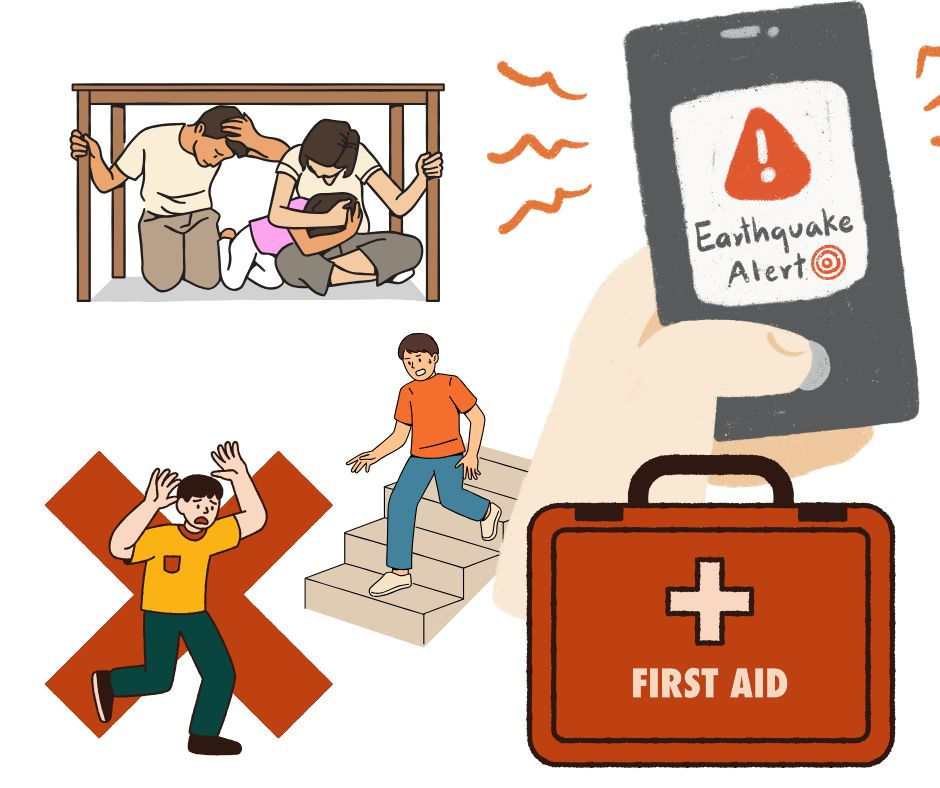
Drop, Cover, and Hold On
This means:
Drop to the ground
Take cover under a sturdy table or desk
Hold on until the shaking stops
People are advised to:
Stay away from windows and glass
Avoid elevators
Protect their head and neck
Remain indoors if already inside a building
If outdoors, moving away from buildings, power lines, and other hazards can reduce the risk of injury.
3. After an Earthquake
The danger does not always end when the shaking stops. Strong earthquakes are often followed by aftershocks that can continue for hours, days, or even weeks.
After an earthquake, individuals should:
Check for injuries
Inspect buildings for damage
Listen to official announcements
Avoid entering unsafe structures
Prepare for possible aftershocks
In coastal areas, residents may also need to monitor tsunami advisories if the earthquake occurred offshore.
School Drills, Workplace Training, and Government Campaigns
Earthquake preparedness is reinforced through regular drills and public awareness campaigns. Schools across the country conduct earthquake simulations to teach students proper safety procedures, while businesses and government offices practice emergency response plans.
National preparedness programs encourage citizens to understand local hazards and participate in disaster readiness activities. These efforts help build a culture of awareness and resilience throughout the country.
Earthquake preparedness is not just about responding to disasters—it is about developing the knowledge, habits, and confidence needed to protect lives when the unexpected occurs.
Earthquake Safety Tips for Travelers
While earthquakes are a natural part of life in the Philippines, visitors can travel confidently by understanding a few basic safety precautions. Most travelers will never experience a significant earthquake during their trip but knowing what to do can help ensure a safer and less stressful experience. These earthquake safety tips for the Philippines are useful for anyone exploring the country's cities, beaches, mountains, and islands.
Know Your Hotel's Safety Procedures
Upon arriving at your accommodation, take a few moments to familiarize yourself with:
Emergency exits
Evacuation routes
Stairwell locations
Emergency assembly areas
Many hotels and resorts in the Philippines have earthquake response procedures in place. Knowing where to go before an emergency occurs can save valuable time if an earthquake strikes.
Understand Local Alerts and Announcements
The Philippines has an active disaster monitoring system that provides updates during significant seismic events.
Travelers should:
Pay attention to hotel announcements
Follow instructions from local authorities
Monitor official news and emergency alerts
Keep a charged mobile phone available
In the event of a major earthquake, local officials may issue safety advisories, evacuation instructions, or tsunami warnings.
What to Do During an Earthquake
If you feel strong shaking, remember the widely recommended safety procedure:
Drop, Cover, and Hold On
Drop to the ground.
Take cover under a sturdy table or desk if available.
Hold on until the shaking stops.
Avoid:
Running during strong shaking
Using elevators
Standing near windows or heavy objects that could fall
If you are outdoors, move to an open area away from buildings, trees, power lines, and other potential hazards.
Be Aware of Coastal Evacuation Procedures
Because some offshore earthquakes can generate tsunamis, travelers staying near beaches or coastal areas should be aware of evacuation routes.
If a strong earthquake occurs near the coast and lasts for an extended period:
Move to higher ground if advised by authorities.
Follow local evacuation instructions.
Do not return to coastal areas until official clearance is given.
Travel With Confidence and Awareness
Earthquakes are a reality in the Philippines, but preparedness and awareness significantly reduce risk. By understanding basic safety procedures, paying attention to local guidance, and remaining calm during emergencies, travelers can explore the country with greater confidence while enjoying its remarkable natural beauty and cultural experiences.
Cultural Reflection – Strength in Uncertainty
Living in the Philippines means living alongside the forces of nature. Earthquakes, typhoons, volcanic eruptions, and floods are realities that many communities have faced for generations. Yet despite these challenges, one of the most enduring characteristics of the Filipino people is their remarkable resilience. The story of Filipino resilience is not simply about surviving disasters—it is about finding the strength to rebuild, adapt, and move forward.
There is a unique relationship between Filipinos and the natural environment. The same forces that bring earthquakes and volcanic activity have also created fertile landscapes, towering mountains, beautiful islands, and some of the country's most breathtaking natural wonders. Nature can be both a source of challenge and a source of blessing, and Filipinos have learned to live with that balance.
In the aftermath of disasters, community cooperation often becomes one of the most powerful tools for recovery. Neighbors help clear debris, families share resources, volunteers assist those in need, and entire communities work together to rebuild homes and livelihoods. This reflects the enduring value of bayanihan—the spirit of collective support that remains deeply rooted in Filipino culture.
Resilience is also expressed through adaptability and hope. Even after significant loss, many Filipinos focus on rebuilding rather than dwelling on hardship. This outlook does not ignore the difficulties of disaster; rather, it reflects a belief that recovery is possible through perseverance, faith, and community support.
Perhaps this is why resilience has become such an important part of Filipino identity. Living on islands shaped by powerful geological forces has fostered a culture that values courage, cooperation, and optimism. The ability to endure uncertainty while continuing to move forward is woven into the national character.
In many ways, the story of earthquakes in the Philippines is also a story about people—about communities that rise after adversity and find strength not only in themselves, but in one another.

Takeaway – A Nation Shaped by the Forces of Nature
Earthquakes are an integral part of the Philippines' geological story. Positioned along the Pacific Ring of Fire and intersected by active fault systems, the country is continually shaped by powerful tectonic forces beneath the Earth's surface. These same forces that generate earthquakes have also created the mountains, volcanoes, islands, hot springs, and dramatic landscapes that make the Philippines one of the most geologically fascinating nations in the world.
While earthquakes remain an unavoidable natural hazard, preparedness plays a vital role in reducing risks and protecting communities. Understanding fault lines, practicing safety procedures, maintaining emergency plans, and supporting public awareness efforts all contribute to a more resilient society.
Perhaps the most inspiring lesson from the Philippines' long history of seismic activity is the resilience of its people. Time and again, Filipinos have demonstrated remarkable adaptability, perseverance, and community spirit in the face of adversity. Through cooperation, faith, and determination, communities continue to rebuild and move forward after even the most challenging disasters.
In many ways, the story of earthquakes in the Philippines is not only about geology—it is also about the strength of the human spirit. The nation's landscapes and its people have both been shaped by the forces of nature.
Explore more Philippine natural wonders, geology, history, and cultural stories on
Frequently Asked Questions
Why are earthquakes common in the Philippines?
Earthquakes are common in the Philippines because the country is located along the Pacific Ring of Fire, one of the most seismically active regions on Earth. The archipelago sits near several tectonic plate boundaries and contains numerous active fault lines. As these plates move and interact, they generate thousands of earthquakes each year.
What was the strongest earthquake in Philippine history?
One of the strongest earthquakes ever recorded in Philippine history was the 1976 Moro Gulf Earthquake, which measured approximately magnitude 8.0. The earthquake triggered a devastating tsunami that affected coastal communities in Mindanao and caused thousands of deaths. It remains one of the deadliest natural disasters in the country's history.
Is the Philippines located on the Ring of Fire?
Yes. The Philippines is located within the Pacific Ring of Fire, a vast belt of active volcanoes and earthquake zones that surrounds much of the Pacific Ocean. This location explains why the country experiences frequent earthquakes, volcanic eruptions, and occasional tsunamis.
Can earthquakes cause tsunamis in the Philippines?
Yes. Strong underwater earthquakes can generate tsunamis if they cause a sudden displacement of the seafloor. Because the Philippines is an island nation surrounded by seas and oceans, certain coastal areas are vulnerable to tsunami hazards. This is why authorities closely monitor major offshore earthquakes and issue tsunami advisories when necessary.
How can travelers stay safe during an earthquake?
Travelers should familiarize themselves with emergency exits and evacuation procedures at their hotel or accommodation. During an earthquake, remember to Drop, Cover, and Hold On. Stay away from windows, avoid elevators, and follow instructions from local authorities. If near the coast after a strong offshore earthquake, pay attention to tsunami warnings and evacuation orders.
Which areas of the Philippines are most earthquake-prone?
Many parts of the country are vulnerable to earthquakes because active faults and tectonic plate boundaries are found throughout the archipelago. Areas near the Philippine Fault System, the Valley Fault System, and various subduction zones experience elevated seismic risk. Regions in Luzon, the Visayas, and Mindanao have all experienced significant earthquakes throughout history.

Bloom Philippines: An Adult Coloring Book
Celebrates the extraordinary beauty of the Philippine islands through more than 50 detailed illustrations inspired by tropical flowers, native plants, and Filipino-inspired decorative patterns. Featuring Sampaguita blossoms, Gumamela flowers, exotic orchids, palm frond mandalas, rainforest botanicals, and tropical island-inspired designs, this collection offers a relaxing and creative escape into one of the world’s richest biodiversity hotspots. Designed for mindfulness, stress relief, and artistic expression, Bloom Philippines is perfect for nature lovers, coloring enthusiasts, and anyone seeking a deeper appreciation of the Philippines’ natural and cultural beauty.



Earthquake is a natural disaster and a remarkable warnings that creates vulnerable boundaries. A faults that has significant history and a vulnerable biodiversity.